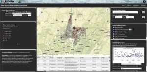
Screenshot of West Virginia’s Quality Impact Portal
The West Virginia Water Quality Impact Portal (WVWQIP) facilitates access to surface and groundwater quality data in the 14 West Virginia counties where Marcellus Shale gas development is most prevalent. The portal allows users to visualize and analyze water quality data in relation to shale gas hotspots and other land uses, providing regulators, educators, and the general public with insight into local water quality trends.
Features of the WVWQIP include:
- Access to data from more than 1.3 million surface and groundwater samples aggregated from local, state, and federal organizations
- A map viewer that allows for quick visualization of monthly mean water quality trends
- An integrated graphing application to investigate temporal trends and water quality parameter relationships
- Esri Story Maps explaining water quality impacts associated with energy development, and
- The ability to upload data into the map viewer or download the full water quality data set for more advanced analyses.
The WVWQIP was developed through funding from an Exchange Network Grant by West Virginia University professors and researchers. Portal creation was facilitated by the West Virginia Department of Environmental Protection, Friends of Deckers Creek, and West Virginia Geological and Economic Survey, which provided access to large quantities of data in digital and pdf file formats. Ongoing work involves the development of virtual learning exercises for high school and undergraduate students who use the WVWQIP as an educational and outreach tool. Exercises include investigating temporal water quality trends and relationships between water quality and shale gas development, coal mining, and other land uses.
For questions about WVWQIP content, please contact Shikha Sharma of West Virginia University. For technical assistance, contact Maneesh Sharma of the West Virginia GIS Technical Center.